Garmin aera 760 Aviation Portable GPS

Garmin aera 760 Aviation Portable GPS
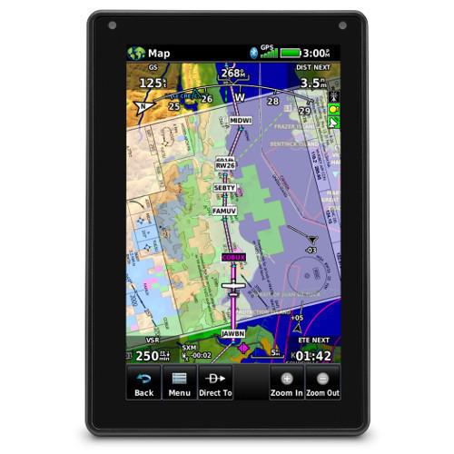
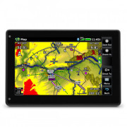
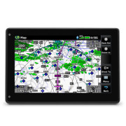
The Garmin aera 760 is a new premium aviation portable GPS that is purpose-built for the pilot and the cockpit. The aera 760 boasts a 7-inch bright, sunlight readable touchscreen display complete with comprehensive chart options in a compact and dedicated portable GPS.
Free Transair Cockpit Bag worth £24.95 with this Garmin GPS!

The Garmin aera 760 is a new all-in-one aviation portable that comes complete with a built-in GPS/GLONASS receiver that is optimized for use in the cockpit. Its bright, 7-inch sunlight readable display can run on battery power for up to four hours on a single charge. Along the bezel, an industry-standard USB-C connection is used to charge and power the aera 760, while a microSD card slot allows pilots to load topography and street maps or use it to easily transfer user waypoints. The aera 760 features an intuitive user-interface resembling that of many other popular Garmin products such as the GTN™ Xi series, G3X™ Touch and Garmin Pilot™ allowing pilots to easily transition between multiple Garmin products in the cockpit. Capable of operating in harsh conditions, the aera 760 has also been tested and hardened to meet stringent temperature and vibration standards.
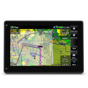
New to the aera 760, pilots can load departures, arrivals and instrument approach procedures (IAPs) within a flight plan, which can be wirelessly transferred to a navigator in the cockpit. Once a procedure is loaded within the aera 760, pilots have the option to view the chart or they can overlay it on the moving map. IFR enroute charts, VFR sectionals and Garmin FliteCharts® are also geo-referenced, providing optimal situational awareness. Jeppesen electronic charts are compatible with the aera 760 and give customers worldwide access to instrument approach chart information. In addition to procedures, victor airways, user-defined holds and holds over an existing navigation fix can be entered into a flight plan.
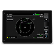
Built-in Wi-Fi® and Bluetooth® allow the aera 760 to take advantage of Garmin Connext wireless connectivity inside and outside of the cockpit. When connected to Wi-Fi, pilots can easily download aviation database and software updates without the need to physically connect it to a computer. Prior to departure, pilots can also view worldwide weather information on the aera 760 when it’s connected to Wi-Fi. In the cockpit, it is capable of wirelessly connecting to select products such as the GTX™ 345 or the GDL® 50 to display the benefits of Automatic Dependent Surveillance- Broadcast (ADS-B) traffic, Flight Information Service-Broadcast (FIS-B) weather1, SiriusXM2 aviation weather and more via Bluetooth. Exclusive features such as TerminalTraffic™ and TargetTrend™ can also be viewed on the moving map and dedicated traffic pages.
Pilots can hard-wire the aera 760’s power, audio and dual RS-232 connections to receive additional benefits. When connected to a navigator such as the GTN 650Xi/750Xi, GTN 650/750 or the GNS 430W/530W, the aera 760 can send and receive flight plan data that is entered into the navigator over a serial port so all products remain synchronized throughout the flight. It is also capable of wirelessly connecting to these navigators when paired with a Flight Stream 210/510. When connected to a NAV/COM such as the GTR 225, GNC 255 or GTR 200, frequencies and airport identifiers can also be transferred from the aera 760 to the corresponding NAV/COM. For aircraft flying in visual conditions, pilots can optionally connect the aera 760 to select autopilots to fly lateral GPS and single point vertical navigation (VNAV) guidance. For example, pilots flying in visual conditions can fly a VNAV profile from their current altitude to pattern altitude using the aera 760 fully coupled to the autopilot.
3D Vision technology displays a virtual 3D perspective view of surrounding terrain, obstacles and airports, as well as a horizontal situation indicator (HSI) that is capable of showing lateral and vertical deviation bars. When the aera 760 is panel mounted or paired with a compatible attitude source such as a GDL® 50 or GTX 345, pilots can view synthetic vision (SVX), which adds the display of back-up attitude information on the portable.
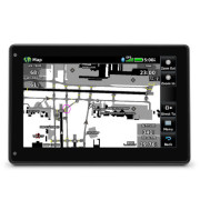
The aera 760 also features fuel price information, an E6B flight computer and weight and balance calculators. The E6B can be used prior to a flight to aid in calculating fuel burn, estimated time of arrival (ETA) and more. While in-flight, the aera 760 utilizes ground speed information to recalculate fuel burn and ETA. Helicopter operators also have access to features tailored to their unique operations, such as WireAware™ wire-strike avoidance technology. WireAware overlays power line locations and relative altitude information on the moving map and provides both aural and visual alerting when operating near power lines. With optional map data, pilots can also enter street intersections or non-aviation waypoints. GPS altitude display is offered in both mean sea level (MSL) and above ground level (AGL), so they are easier to identify relative to the aircraft flight path.
In The Box:
- Mount cradle with CLA power cable
- USB-C 27W AC adapter
- USB-C to USB-C cable
- USB-C to USB-A cable
- Quick start manual and related documentation
Physical & Performance:
- Physical dimensions: 7.29”W x 4.85”H x 0.91”D (18.5 x 12.3x 2.3 cm)
- Display size: 7" diag (17.8 cm)
- Display resolution, WxH: 480 x 800; portrait and landscape orientation
- Display type: touchscreen WVGA color TFT with white backlight
- Weight: 19.8 oz (561 g)
- Battery: Rechargeable lithium-ion
- Battery life: Up to 4 hours during most daytime conditions, (80% backlight)
- SBAS/WAAS/GLONASS receiver: high-sensitivity with WAAS position accuracy
- Voltage range: 10-35
- Route Data: VFR/IFR
- USB connection: yes (USB-C)
- Expandable memory: yes (microSD™ cards)
This device is not approved for primary IFR navigation.